We hope you love the great outdoors as much as we do! That’s why we have published a selection of our favourite trail and road running (or hiking) routes in and around South Oxfordshire. They vary in length and amount of climb and are different in character, but they all highlight our lovely countryside.
The trails can be hot, dry and dusty in Summer and cold, wet and muddy in Winter. So, please dress and take precautions appropriately for each season. Also, don’t forget to follow the Countryside Code.
You may find England Athletics’ general advice on running safety helpful. If you are new to trail running you might want to look at Runner’s World magazine’s advice for those new to this activity.
If you have any comments or corrections please use the e-mail contact address via the link at the bottom of each of the web pages.
Using the routes
The routes can be used in various ways, but we recommend using a smartphone app to view the route while you run. We provide a GPX file of the route as a download and this can be imported into most smartphone apps (and many sports watches!). If you wish to edit or reverse the route you can do this using an online GPX editor such as https://gpx.studio/ and then use your own GPX file.
There are many running apps available now, so we don’t recommend any particular one. Some of the free services don’t allow route mapping so its best to check before you sign up for them.
If you don’t have access to a smartphone or fancy sports watch then just print off the OS map image and carry it in a Ziploc bag, or better still buy an OS map!
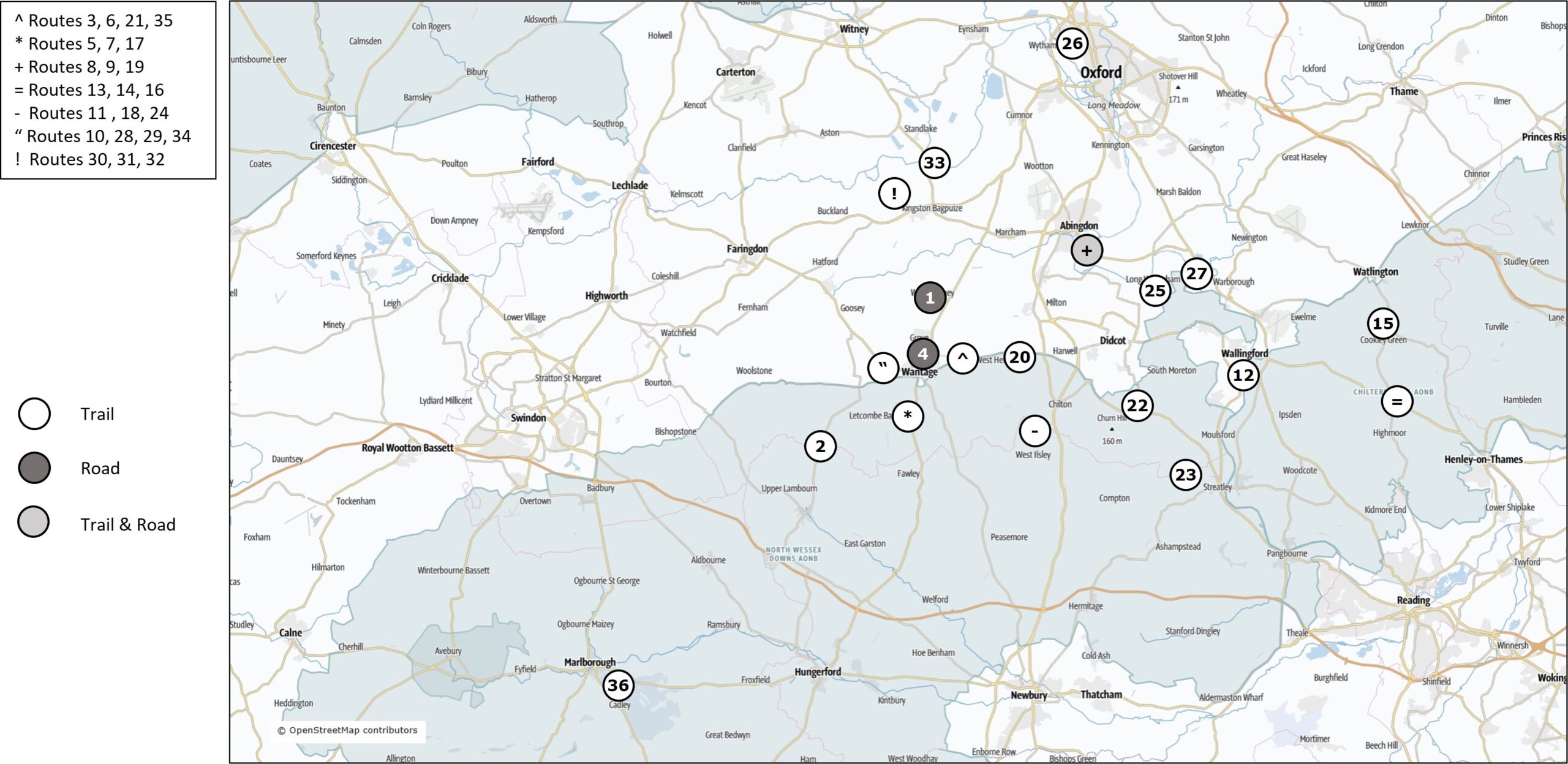
Index to routes
| Route distance | Fairly flat or rolling | Quite hilly |
| 5-10km (3-6 miles) | 1*, 6, 9, 17, 18, 19*, 20, 22, 31, 33, 34 | 5, 25, 28 |
| 10-15km (6-9 miles) | 2, 8, 24, 30, 32, 35 | 7, 14, 23, 26, 27, 29 |
| More than 15km (9 miles) | 3, 4*, 11, 12 | 10, 13, 15, 16, 21, 36 |
List of routes with link to description of each
- Hanney (7.9km/4.9miles, 10m/33ft ascent)
- Sparsholt Firs – Red Barn (10.2km/6.3m, 140m/450ft)
- Ardington – Harwell – Ridgeway (16km/10m, 200m/656ft)
- Wantage – Goosey (19.4km/12m, 120m/394ft)
- Court Hill Centre (8.5km/5.3m, 140m/460ft)
- Ardington – West Hendred (6.5km/4m, 70m/230ft)
- Court Hill Centre (11.6km/7.2m, 230m/755ft)
- Rye Meadow – Lower Radley (12.1km/7.5m, 2m/6ft)
- Rye Meadow – Thrupp Lake (7.8km/4.8m, 0m/0ft)
- Childrey – Ridgeway (15.5km/9.6m, 250m/820ft)
- Bury Down – Old Street (16.6km/10.3m, 190m/623ft)
- Wallingford – Goring (21.6km/13.4m, 60m/197ft)
- Nettlebed – Hambleden (29.3km/18.2m, 550m/1800ft)
- Nettlebed (10.8km/6.7m, 270m/886ft)
- Cookley Green – Christmas Common (23.4km/14.5m, 530m/1740ft)
- Nettlebed – Henley – Stonor Park (25.4km/15.8m, 490m/1608ft)
- Court Hill Centre – Letcombe Castle (7.4km/4.6m, 80m/262ft)
- Bury Down – West Ilsley (7.9km/4.9m, 90m/295ft)
- Abingdon (9.1km/5.7m, 30m/98ft)
- East Hendred (5.7km/3.5m, 60m/197ft)
- Ardington – Ridgeway (17.6km/10.9m, 290m/950ft)
- Blewbury Down (8.4km/5.2m, 90m/295ft)
- Ridgeway – Roman Temple (12.6km/7.8m, 260m/853ft)
- Bury Down – Compton (13.5km/8.4m, 130m/427ft)
- Paradise Wood (5.8km/3.6m, 70m/227ft)
- Wolvercote – Wytham (11km/6.8m, 180m/590ft)
- Dorchester Shillingford – Clumps (11km/6.8m, 125m/410ft)
- Childrey – Letcombe Bassett Nature Reserve (7.5km/4.7m, 125m/410ft)
- Childrey – Kingston Lisle – Ridgeway (12km/7.5m, 200m/656ft)
- Longworth – Buckland – Duxford (11km/6.8m, 60m/197ft)
- Longworth – Shifford Lock (8km/5m, 55m/180ft)
- Longworth – Tenfoot Bridge (11km/6.8m, 40m/130ft)
- Newbridge – Northmoor (9.5km/5.9m, 0m/0ft)
- Childrey – Westcot (8km/5m, 60m/197ft)
- Ardington – Harwell – West Ginge (13km/8.1m, 120m/394ft)
- Savernake Forest (21km/13m, 260m/853ft)